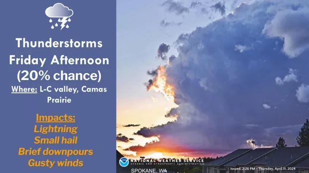
SPOKANE, WA—The National Weather Service is monitoring the potential for strong thunderstorms to develop over northeast Oregon, eastern Washington, and north-central Idaho tomorrow afternoon. There is a 20% chance of even stronger storms impacting the Lewis-Clark Valley, Camas Prairie, and the Blue Mountains. This weather system could include thunderstorms, hail, and isolated wind gusts exceeding 35 miles per hour.
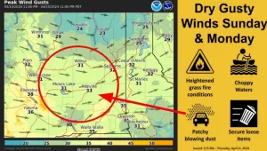
Officials say a small chance for thunderstorms will linger around this region throughout the weekend, followed by a strong cold front that will deliver widespread dry, windy conditions late Sunday into Monday. This will usher in the risk of grass fires.
NWS says, “Westerly winds increase Sunday into Monday as a front passes through the region. Dry conditions will lead to an elevated threat of grass fires.”
“Sustained Winds of 15-30 mph with gusts of 25-40 mph are likely for the Wenatchee area, Waterville Plateau, the Columbia Basin, West Plains, and Palouse. Breezy winds with 20-30 mph gusts are likely elsewhere. Patchy blowing dust is possible near recently plowed fields (moderate confidence),” according to the NWS.
A Puget Sound Convergence Zone could bring a brief period of moderate snow accumulations to the Cascade passes on Monday.
“Snow levels will plummet behind the front, with snow showers possible down to valley floors Tuesday AM,” the NWS says.
Wind Impacts:
• Loose or unsecured objects may be blown away.
• Dangerous boating conditions on area waters due to strong winds and significant wave activity.
• Reduced visibility from blowing dust near recently plowed fields
For the latest forecast updates, visit weather.gov/Spokane.