From the National Weather Service in Spokane:
|
| KEY POINTS |
- Windy with rapid fire spread possible with any new or existing fires Monday, with dry and breezy winds on Tuesday as well
- Patchy blowing dust Monday Waterville Plateau, Upper Columbia Basin, Pomeroy area (Confidence Low-Moderate)
|
| CHANGES FROM PREVIOUS BRIEFING |
| Increased confidence on winds |
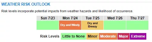
| WEATHER RISK OUTLOOK |
| Risk levels incorporate potential impacts from weather hazards and likelihood of occurrence. |
| Sun 7/23 |
Mon 7/24 |
Tue 7/25 |
Wed 7/26 |
Thu 7/27 |
|
Dry and Windy |
Dry and Breezy |
|
|
| Risk Levels |
Little to None |
Minor |
Moderate |
Major |
Extreme |
|
| DETAILS |
- Strongest winds are expected on Monday with widespread breezy to windy conditions
- Probability of 25 MPH or higher wind gusts: 80-100% except less than 50% valleys in Central ID Panhandle.
- Probability of 40 MPH or higher wind gusts: 80% Pomeroy/Alpowa Summit area, 60% Waterville Plateau and Wilbur area, 30-50% Moses Lake Area, Okanogan Valley, West Plains.. Elsewhere chances are less than 30%.
- These winds have the potential to kick up patchy blowing dust, especially near any recently plowed fields
|