
SPOKANE, WA—The National Weather Service says a potent cold front will usher strong winds into the Inland Northwest over the weekend. In addition to southeast Washington and north-central Idaho, areas expected to be impacted include the east slopes of the Cascades, Columbia Basin, Palouse, Waterville Plateau, the Spokane-Coeur d’Alene area, and the southern Panhandle.
Meteorologists predict breezy conditions will last for the next few days, beginning later today with winds out of the northeast with gusts of 25 to 35 miles per hour.
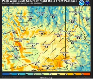
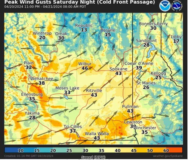
“On Saturday night, a potent cold front will swing through the region, shifting winds to west/southwest. Winds with the frontal passage have the potential to become strong for a few hours with sustained speeds near 30 mph and gusts to 45 mph. Blustery westerly winds will continue on Sunday with gusts up to 35 mph,” the NWS says.
The high winds could cause hazy conditions in some regions, especially near recently plowed fields. Blowing dust can produce a visibility of one mile or less.
Officials say several days of dry, breezy conditions will also raise concerns about fire spread in dry grasses and timber litter left behind by last year’s fires.
Those traveling over the Washington Cascades can expect snow showers that will cause slushy driving conditions, particularly on Stevens Pass.
For the latest forecast updates, visit weather.gov/spokane.