NWS Holiday Weekend Travel Outlook

nwsholidays122123
KEY POINTS
  • Light Snow – Impacting Mountain Passes Friday into Early Saturday
  • Minor if any snowfall outside of the mountains.
  • Periods of light accumulating snow will continue mainly in the Cascades Sunday through next week creating winter driving conditions.
CHANGES FROM PREVIOUS BRIEFING
Winter weather advisory has been issued for Stevens Pass.
WEATHER RISK OUTLOOK
Risk levels incorporate potential impacts from weather hazards and likelihood of occurrence.
Fri 12/22 Sat 12/23 Sun 12/24 Mon 12/25
Mountain Snow Light Mountain Snow ID Light Rain/Snow
Risk Levels Little to None Minor Moderate Major Extreme
DETAILS
WHAT WHEN WHERE IMPACTS
Mountain Pass Snow
Confidence: High
Friday into Early Saturday Mainly Stevens Pass, but also other passes like Blewett, Sherman, & Lookout Passes 
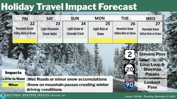
Winter travel conditions across mountain passes over the busy holiday weekend.
Probabilities of snowfall over the Passes:
Stevens Pass: 70% chance of 6 inches; 40% chance of 8 inches; 5% chance of 12 inches or more.
Blewett Pass: 50% chance of 1 inch; 10% chance of 2 inches.
Loup Loup: 15% chance of 1 inch.
Sherman Pass: 55% chance of 1 inch; 25% chance of 2 inches.
4th of July Pass: 40% chance of 1 inch; 15% chance of 2 inches.
Lookout Pass: 65% chance of 1 inch; 30% chance of 2 inches; less than 5% chance of 4 inches.
Christmas Day
Confidence: Moderate
Monday Region Wide 20% chance of mountain snow and valley rain or snow for eastern WA and north ID. Probabilities go up to 60% chance of light snow across the Cascade mountains.
Valley accumulations would be minor if any.
Stevens Pass: 55% chance of 1 inch; 40% chance of 2 inches; 20% chance of 4 inches or more.
FOR MORE INFORMATION
For the latest forecast updates, visit weather.gov/spokane.