
SPOKANE, WA – The National Weather Service says the Inland Northwest will receive some snow through Sunday. That will be followed by a rapid warming that will bring rain.
From the NWS:
- Multiple feet of snow for the Cascade passes Thursday Night through Sunday. 80-95% chance of 2 feet, 40-70% chance of 3 feet.
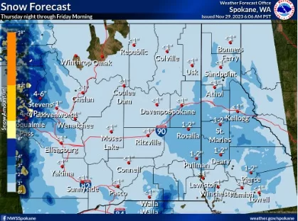
- Light to moderate snow accumulations for the lowlands of Eastern WA and the ID Panhandle Thursday night through Sunday.
- Rapid warming with rain late this weekend & early next week likely lead to rapid snow melt and possible minor flooding.
- Air Stagnation continues through Thursday.
-
CHANGES FROM PREVIOUS BRIEFING • Increased snow amounts Thursday night through Saturday in the lowlands
• Increased snow amounts in the Cascades Friday and Saturday
• Decreased snow amounts for Stevens Pass SundayWEATHER RISK OUTLOOK Risk levels incorporate potential impacts from weather hazards and likelihood of occurrence. Wed 11/29 Thu 11/30 Fri 12/1 Sat 12/2 Sun 12/3 Mon 12/4 Tue 12/5 Snow Chance PM Snow Widespead light/moderate snow NE WA/ID Panhandle. Heavy in the Cascades Widespead light/moderate snow NE WA/ID Panhandle. Heavy in the Cascades Light snow NE WA/ID Panhandle. Heavy North Cascades Light to moderate snow above 6000′ Air Stagnation Most of eastern WA and north ID Most of eastern WA and north ID Precipitation/Flooding Moderate Rain SE WA/Southern Panhandle Light Rain SE WA/ID Panhandle Light to moderate rain with rapid warming. Minor flooding possible SE WA into NC ID? Light to moderate rain with rapid warming. Minor flooding possible SE WA into NC ID? Risk Levels Little to None Minor Moderate Major Extreme DETAILS FOR MORE INFORMATION For the latest forecast updates, visit weather.gov/spokane.