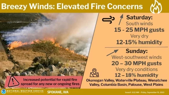
SPOKANE, WA – The National Weather Service says a ridge of high pressure will result in warm and dry conditions leading into this weekend. A cold front will swing through Saturday night bringing breezy southerly winds up the Okanogan Valley on Saturday ahead of the front followed by breezy westerly winds across much of eastern Washington and North Idaho by Sunday afternoon.
The frontal system will be dry and little to no rainfall is expected. The combination of warm temperatures with dry air and breezy winds will bring elevated fire weather conditions to the Inland Northwest, especially on Sunday with westerly winds impacting much of the region.
|
| KEY POINTS |
- Warm and dry conditions into the weekend. Local smoke/haze impacts possible from nearby fires.
- Elevated fire weather concerns due to dry conditions and breezy southerly winds up the Okanogan Valley on Saturday and regionwide breezy westerly winds on Sunday.
|
| CHANGES FROM PREVIOUS BRIEFING |
| Increased confidence of gusty winds and very dry conditions Saturday and Sunday. Stronger wind gusts both days. |
| WEATHER RISK OUTLOOK |
| Risk levels incorporate potential impacts from weather hazards and likelihood of occurrence. |
| Fri 9/15 |
Sat 9/16 |
Sun 9/17 |
Mon 9/18 |
|
Dry and Breezy
Okanogan Valley |
Dry and Breezy
Elevated Fire
Weather Conditions |
Breezy
Cooler |
| Risk Levels |
Little to None |
Minor |
Moderate |
Major |
Extreme |
|