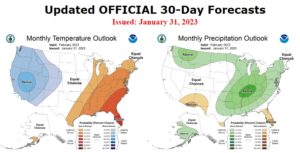
SPOKANE, WA – The Climate Prediction Center has issued an updated outlook for February. Elevated odds of cooler than normal temperatures and above normal precipitation are forecast for the Inland Northwest.
From NWS:
The current state of the El Niño Southern Oscillation (ENSO) remains in the negative phase with the latest weekly observed Niño 3.4 Index value standing at -0.6 degrees Celsius. Meanwhile, the amplitude of the Madden Julian Oscillation (MJO) has increased during late January over the east-central Indian Ocean and is forecast to propagate eastward to the Maritime Continent and West Pacific through mid-February.
The Arctic Oscillation (AO) and North Atlantic Oscillation (NAO) have both been in the positive phase in recent days while the Pacific North American (PNA) pattern has transitioned to the negative phase. Composites derived from the recent evolution of ENSO and extra-tropical indices depict anomalous ridging off the west coast of North America as well as over the southeastern Contiguous United States (CONUS).
Anomalous troughing is indicated across the Northern Plains to much of the Interior West. However, MJO composites show anomalous ridging over the eastern CONUS stretching westward across much of the Plains. Additionally, MJO composites depict increased troughing over Alaska relative to composites derived from ENSO.
The competing influences from ENSO and the MJO introduces increased uncertainty across large portions of the forecast domain. The current robust MJO event is expected to be a significant driver for the evolution of the overall pattern during the month of February and is a major factor in contributing to modifications in the current updated outlooks as compared to the February Outlooks issued on January 19 (herein referred to as the mid-month outlooks).
In addition to analysis of the current evolution of ENSO, the MJO, and extratropical indices such as the AO, NAO, and PNA, short term dynamical model guidance is relied upon with the official short and medium range outlooks from the Weather Prediction Center (WPC), 6-10 Day and 8-14 Day Outlooks from the Climate Prediction Center (CPC), and Weeks 3-4 Outlooks from CPC contributing significantly to the updated February 2023 outlooks.
Dynamical model guidance from the Climate Forecast System Version 2 (CFSv2), the Global Forecast System (GFS), the European Centre for Medium Range Weather Forecasts (ECMWF), and Environment and Climate Change Canada (ECCC) were utilized to supplement the official outlooks. Antecedent conditions such as extratropical Sea Surface Temperatures (SSTs), sea ice extent, and snow cover anomalies also were factors in the construction of the February Outlooks where appropriate.
Short and medium range outlooks from WPC and CPC as well as ENSO-based statistical guidance are in good agreement in favoring above normal temperatures across much of the eastern CONUS. MJO composites also support an expansion of milder than normal conditions westward across most of the Plains.
Therefore, the areal extent of enhanced above normal temperature probabilities is increased relative to the mid-month outlook and now covers most of the eastern third of the CONUS. One exception is for northern New England, where EC is indicated due to the potential for a brief cold snap early in the month. Due to the warm signal shown by MJO-based composites over the central CONUS, enhanced below normal temperatures depicted in the mid-month outlook over the Northern Plains has been removed and Equal Chances (EC) is now depicted across this region.
Conversely, dynamical model guidance from the CFSv2 is much colder across the southwestern CONUS relative to guidance available in mid-January. This trend in the CFSv2 as well as support from CPC’s 6-10 Day, Week-2, and Weeks 3-4 outlooks led to an expansion of enhanced below normal temperature probabilities across the CONUS from the Rockies westward. Anomalous snow cover is also a contributing factor in increasing chances of below normal temperatures across parts of the West.
Uncertainty is very high for the temperature outlook across the state of Alaska. Composites derived from MJO and ENSO yield conflicting signals with the former producing a much colder signal across western parts of the state. Conflicting signals are also evident across time scales as the CPC 6-10 Day and Week-2 outlooks tilt cold across northern and western Alaska while the CPC Weeks 3-4 outlooks depict the opposite.
Due to these uncertainties, EC is indicated across much of Alaska. The lone exception is across the Aleutians and Alaska Peninsula, where a slight tilt toward above normal temperatures is indicated based primarily on current observations of above normal SSTs and below normal sea ice extent. An active pattern is likely across much of the eastern CONUS as short and medium range guidance from WPC and CPC generally support above normal precipitation across much of the region.
Guidance from the CFSv2 has trended south in bringing increased chances of above normal precipitation chances across much of the Southeast and Lower Mississippi Valley, and Southern Plains, in-line with current WPC and CPC short and medium range outlooks. Therefore, the area of enhanced above normal precipitation chances has expanded across the eastern and central CONUS relative to the mid-month outlook and now extends southward to the Southeast, Gulf Coast, Lower Mississippi Valley, and Southern Plains.
Correspondingly, areas of enhanced below normal precipitation probabilities are suppressed to the Florida Peninsula and southern Texas. Increased uncertainty is evident farther to the west, along the West Coast of the CONUS. The CFSv2 has trended drier along the West Coast relative to mid-month and ENSO and MJO-based composites yield conflicting signals.
These factors, combined with relatively weak probabilities depicted in CPC’s 6-10 Day, Week-2, and Weeks 3-4 outlooks resulted in a forecast of EC along the West Coast of the CONUS. Above normal precipitation is still favored for the Northern Rockies, where CPC outlooks at various time scales within the month of February are in general agreement. Conversely, a tilt toward below normal precipitation is indicated for parts of the Southwest, consistent with the CPC Weeks 3-4 outlooks and with recent February trends .
A tilt toward above normal precipitation is indicated for much of western and southern Alaska, consistent with ENSO composites, CPC official Week-2 and Weeks 3-4 outlooks, and the latest CFSv2 guidance.
*******************************************************************************
****** Previous mid-month discussion below ******
*******************************************************************************
The February 2023 outlooks are issued against the backdrop of an ongoing La Niña event and a weakening Madden Julian Oscillation (MJO) signal. The latest Niño 3.4 weekly sea surface temperature (SST) departures stood at -0.7 degrees Celsius. During the last two months, negative subsurface temperature anomalies weakened, but weak anomalies continue to reside near the surface of the central and eastern Pacific Ocean.
Meanwhile, the magnitude of the Real-time Multivariate (RMM) based MJO index has weakened and has become quasi-stationary over the Western Hemisphere during the past week. However, there is general agreement on the development of a well organized and potentially robust Indian Ocean MJO event during the next two weeks.
Farther to the north, across the extratropics of the Northern Hemisphere, the Arctic Oscillation (AO) has been predominantly negative during early January while the North Atlantic Oscillation (NAO) has generally been positive. Meanwhile, the Pacific North America (PNA) index has exhibited a weakening positive signal and has switched to the negative phase during the past few days.
Combined natural analog composites derived from the recent evolution of equatorial Pacific, MJO, and extratropical indices depict a 500-hPa flow pattern for the month of February dominated by below normal heights across the Northern Plains. Anomalous ridging is generally favored over the eastern North Pacific and across the southeastern Contiguous United States (CONUS).
Trends during the last 15 years favor above normal heights across most of Alaska and the southeastern CONUS and below normal heights over the Northern Plains during the month of February. Natural analog composites, trends, dynamical guidance from the Copernicus Climate Change Service (C3S), North American Multi-Model Ensemble (NMME), and the Coupled Forecast System Version 2 (CFSv2), as well as input from the Climate Prediction Center (CPC) Weeks 3 and 4 Outlooks form the basis of the February outlooks.
Antecedent conditions such as extratropical SSTs, sea ice extent, and snow cover anomalies were also considered where appropriate. Below normal temperatures are favored for the Alaska Panhandle, the Pacific Northwest, and Northern California eastward to the Northern Plains, consistent with dynamical model guidance from the CFSv2 and with anomalous troughing depicted by natural analog composites and trends across the north-central CONUS.
Conversely, dynamical model guidance supports enhanced above normal temperature probabilities across the Southeast, extending northward to southern New England and westward to parts of the Southern Plains. The highest probabilities of above normal temperatures (greater than 50 percent chances) are indicated for the Florida Peninsula northward to coastal areas of South Carolina, associated with anticipated anomalous ridging. Above normal temperatures are also favored for northern and western Alaska, consistent with dynamical model guidance and with current below normal sea ice extent, above normal sea surface temperatures in ice-free regions, and recent trends.
Equal chances (EC) of above, near, and below normal temperatures are indicated across the southwestern CONUS, Central Plains, much of the Great Lakes, parts of the Northeast, and much of Mainland Alaska due to weak or conflicting dynamical and statistical guidance. Dynamical and statistical guidance are in good agreement in depicting increased chances of above normal precipitation across the Ohio Valley, Great Lakes, and much of the Middle and Upper Mississippi Valley, associated with an anticipated enhanced baroclinic zone.
Below normal precipitation is favored farther to the south, across much of the Southeast, consistent with predicted mean anomalous ridging. Increased chances of below normal precipitation extend westward along much of the southern tier of the CONUS due to good agreement among NMME, CFSv2, and C3S guidance. Conversely, a tilt toward above normal precipitation is indicated along most of the Northern Tier of the CONUS where dynamical model guidance is in general agreement. Above normal precipitation is also favored across parts of western Mainland Alaska, where natural analog composites depict enhanced moist southwesterly mid-level flow.
EC of above, near, and below normal precipitation are indicated from California eastward to much of the Central and Southern Plains, parts of the Lower Mississippi Valley and Southeast, coastal areas of the Mid-Atlantic and Northeast, and for much of Alaska due to weak or conflicting dynamical and statistical guidance.
FORECASTER: Scott Handel
The climatic normals are based on conditions between 1991 and 2020, following the World Meteorological Organization convention of using the most recent 3 complete decades as the climate reference period. The probability anomalies for temperature and precipitation based on these new normals better represent shorter term climatic anomalies than the forecasts based on older normals.
Climate Prediction Center – OFFICIAL 30-Day Forecasts