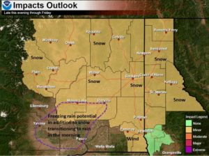
SPOKANE, WA – The National Weather Service says the Inland Northwest can expect some freezing rain and light snow tonight through tomorrow. Breezy conditions will also arrive across southeast Washington and the southern Idaho Panhandle tomorrow.
| Light Snow and Freezing Rain Thursday Night through Friday |
| KEY POINTS |
- Light lowland snow tonight through Friday evening regionwide except the L-C valley
- Light freezing rain in the Lower Columbia Basin late tonight and early Friday morning
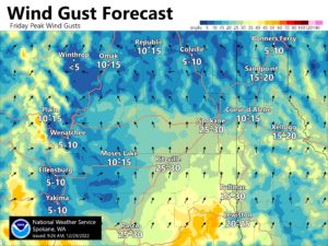
- Breezy winds Friday across southeast Washington and the southern Idaho Panhandle.
|
| CHANGES FROM PREVIOUS BRIEFING |
| Winter weather advisories for most of the region |
| WEATHER RISK OUTLOOK |
| Risk levels incorporate potential impacts from weather hazards and likelihood of occurrence. |
|
Thu 12/29 |
Fri 12/30 |
| Freezing Rain |
Lower Columbia Basin Late |
Lower Columbia Basin Early |
| Snow |
Cascades
Central Washington |
Regionwide except LC Valley |
|
| WHAT |
WHEN |
WHERE |
IMPACTS |
- Snow
- Confidence: Moderate
|
Thursday Night through Friday Evening |
Regionwide |
Snow will begin this evening in the Cascades/Central Washington and spread eastward into Friday. Heavy wet snow in the lowlands could cause slushy and slick roads. Heaviest snow will accumulate overnight and early Friday morning, impacting the morning commute. Min temperatures around freezing could lead to some lower snow accumulations for the Spokane/Coeur d’Alene areas and down the Palouse. |
- Freezing Rain
- Confidence: Low
|
Thursday Night into Friday Morning |
Lower Columbia Basin |
Freezing rain will begin late this evening in the lower Columbia Basin and potentially go as far north as I-90 around Moses Lake and Ritzville. Confidence is low for how far north freezing rain may occur. Ice accumulations will be about a tenth of an inch or less and untreated surfaces could be slick. |
|
| FOR MORE INFORMATION |
| For the latest forecast updates, visit weather.gov/spokane. |