

SPOKANE, WA – The National Weather Service says there will be very active weather conditions over the next few days, including wind, rain, snow, and flooding. Windy conditions will arrive today and continue through tomorrow in southeast Washington, the Spokane area, and the Columbia Basin. Stream and river flooding is also expected in some areas of southeast Washington and the southern Idaho Panhandle.
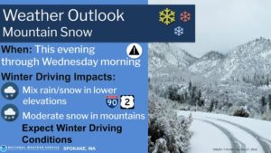
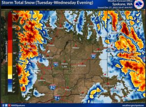
Snow rates in excess of an inch an hour Tuesday into Wednesday for the Cascades and Idaho Panhandle above 3,500 feet with light lowland snow Thursday into Friday regionwide.
|
Tuesday into Wednesday | Cascades and ID Panhandle | Snow covered roads will result in difficult travel conditions. Expect winter travel conditions over mountain passes. Heaviest snow will fall Tuesday night above 3500′ with snow rates reaching an inch an hour. |
|
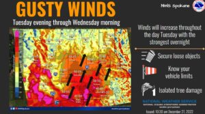
Tuesday into Wednesday | Southeast WA, Columbia Basin, and Spokane Area | South winds will ramp up Tuesday evening to 20-30 mph with gusts around 45-55 mph with localized gusts up to 60 mph. Strongest gusts are expected near the Blue Mountains Tuesday evening. Tree limbs could be blown down and scattered power outages may result. |
|
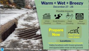
Tuesday into Wednesday | Southeast WA and Southern ID Panhandle | Lower elevation rain has lead to significant snowmelt on top of the significant rain that has fallen. Make sure to clear drainage areas from ice and snow to allow for runoff. This could also lead to urban flooding and cause small streams to rise. |
|
Thursday into Friday | Regionwide | Another weather system will bring light lowland snow regionwide. Travel could be impacted at the mountain passes. |
| KEY POINTS |
|
| CHANGES FROM PREVIOUS BRIEFING |
| • Wind speeds have increased from Tuesday into Wednesday • Snow amounts have increased for the Cascades and ID Panhandle above 3500 feet Tuesday night into Wednesday |
| WEATHER RISK OUTLOOK |
| Risk levels incorporate potential impacts from weather hazards and likelihood of occurrence. |