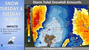

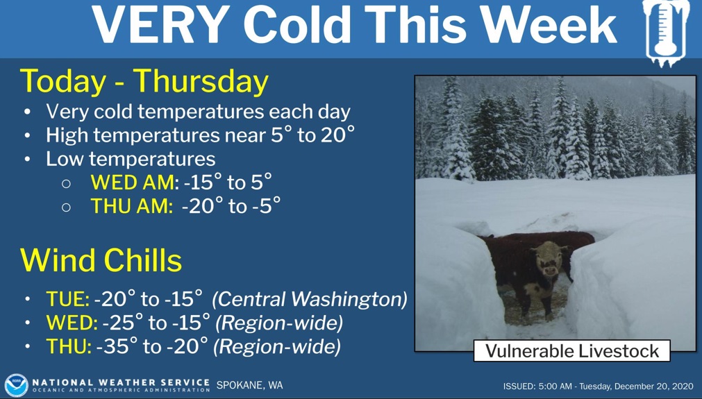
SPOKANE, WA – An Arctic air mass is pushing into the region. Bitterly cold north to northeast winds behind the Arctic front will deliver dangerously cold wind chill values through Thursday. Moisture along the Arctic boundary through tonight will result in heavy snow over the Cascades, Idaho Panhandle, and over the Palouse.
“New snow will be light and fluffy and will have a propensity to blow around with north to northeast winds,” the National Weather Service says.
Another round of moderate to heavy snow is expected Friday into Saturday.
“This system will usher warmer temperatures with a transition to freezing rain the evening of Christmas Eve and through the holiday weekend. There is increasing confidence for freezing rain but low confidence for ice amounts and impacts. Confidence is increasing for mild temperatures and wet conditions going into next week with weather hazards transitioning to the potential for flooding impacts,” the NWS adds.
| KEY POINTS |
|
| CHANGES FROM PREVIOUS BRIEFING |
| • Increased snow amounts for Idaho Panhandle and portions of extreme eastern WA. Winter storm warnings expanded in the North Panhandle. • Earlier end times to the snow and winter weather highlights • Added wind chill advisories through Tuesday morning down the Okanogan Valley and onto the Waterville Plateau. • Added a wind chill watch for the potential of dangerously cold wind chill values Tuesday night through Thursday night. • Slight adjustments to temperatures Wednesday into Thursday. Colder than Monday’s predictions. • Added various winter storm warnings and winter weather advisories over portions of eastern Washington and the Idaho Panhandle for snow through Tuesday. • Increased the potential for freezing rain over the Christmas Holiday weekend. • We will be using hashtag #INWExtremeCold on social media post Partners are encouraged to used hashtag with social media posts to increase visibility. |