LISTEN TO STORY:
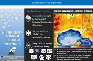
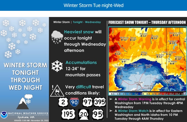
SPOKANE, WA – The National Weather Service says the Inland Northwest can expect a major winter storm to roll in this afternoon between 3:00 and 6:00 p.m. Temperatures will tumble into the teens and single digits tonight. The slow-moving winter storm will spread snow into the Inland Northwest with some of the heaviest accumulations occurring on Wednesday across the northern third of central and eastern Washington into the Idaho Panhandle. Bands of light to moderate snow will likely linger into Thursday and Friday over north Idaho and parts of eastern Washington.
For tonight, the snow will be light but has the potential to impact the evening commute. This snow for north Idaho and far eastern Washington will taper off before the main event arrives early Wednesday morning.
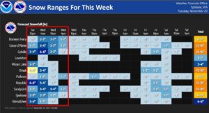
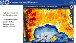
Snow amounts will vary by location, but a general idea is the southern portion of our forecast area (south of I-90 in the Columbia Basin, the Palouse, and into the Camas Prairie) will see 1 to 6 inches of snow. The central part of the forecast area (Wenatchee to Lookout Pass) will see 5 to 10 inches. The Cascade mountains could see 1 to 2 feet. And areas across the north (Omak to the Montana border) are forecast to see 8 to 12 inches, with higher amounts in the mountains.
The snow will cause impacts to the commutes starting as early as this evening in central Washington and continuing as late at Thursday morning for the Idaho Panhandle and extreme eastern Washington.
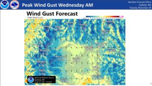
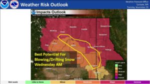
Breezy winds Wednesday afternoon will create areas of blowing and drifting snow…mainly for the upper Columbia Basin (Lincoln County), southern portions of Spokane County, and parts of the Palouse. In addition, visibility could be quite poor in the blowing snow.
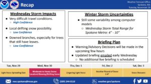
“Another thing to think about is tree damage. Many trees across the Spokane area still have leaves. I am making the assumption that is the case for other locations as well. If you have leaves still on trees and 6+ inches of snow falls, there could be tree damage as well,” according to the National Weather Service’s Laurie Nisbet.
From NWS:
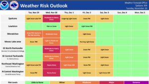
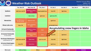
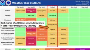
Thursday through Monday: Active and unsettled weather will continue Thursday through the weekend into early next week. Thursday, the upper level trough associated with the system forecasted to give us moderate to heavy snow on Wednesday will move across the Inland Northwest. This will give the region continued chances for snow Thursday and Friday. Friday, the airmass looks to be quite unstable which will support snow showers across eastern Washington and the Idaho Panhandle. Similar to the set up on Monday, snow showers could produce locally heavier amounts. Models suggest a brief, transient shortwave ridge to move through late Friday afternoon into the evening hours before the next wave from a deep trough digging into Oregon and northern California brings increasing snow chances for Saturday. Moving into early next week (Monday/Tuesday) models are bringing another system from the north for more chances for snow and much colder temperatures. With this being so far out, there are still many discrepancies among the ensembles, but the overall message of active and cold weather continues.
From 4AM Thursday through 4AM Sunday, the NBM4.1 is giving far eastern Washington a 50 to 70% chance to see at least an additional 4 inches of snow during this timeframe and a 30 to 60% chance to see at least 6 inches. Probabilities increase as you move into north Idaho where there is a 70 to 100% chance to see at least 4 inches, and a 50 to 70% chance to see at least 6 inches. Lookout Pass will see higher amounts with a 90% chance to see at least 6 inches, an 80% chance to see at least 8 inches, and a 65% chance to see 12 inches.
Temperatures will remain below average Thursday through Monday and beyond. Highs and lows across our northern zones will be in the teens to mid 20s and single digits to teens, respectively. For our southern zones, highs will be in the mid 20s to